A mobile Israeli climate lab in Kenya is capturing real-time data to close Africa’s climate knowledge gap and improve global models.
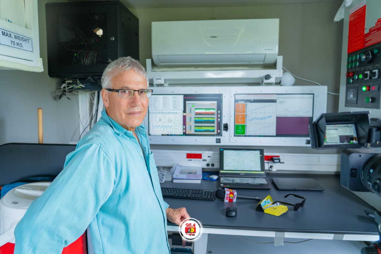
On the dusty plains of Kapiti Conservancy, a white mobile laboratory hums quietly beside the grassland, its roof lined with instruments and its interior packed with computers, sensors and tubing that turn the landscape into data.
To the casual eye, it looks like an ordinary truck. In practice, it is a moving observatory — one designed to measure, in real time, the invisible exchanges between land, air, water and heat that shape how ecosystems survive in a warming world.
For the past two months, the travelling lab — run by the Weizmann Institute of Science — has been stationed at the International Livestock Research Institute (ILRI) facility in Kapiti, Machakos County, quietly tracking exchanges between land, vegetation and the atmosphere.
When Capital FM visited the site, scientists moved between towers of sensors and cables stretching into the grassland. The real laboratory extends far beyond the truck itself — into the soil, the trees and the air above them.
The unit is the first of its kind in Africa and is being used to collect high-resolution measurements on carbon, water vapour, radiation and vegetation activity.
Scientists say the aim is not simply to understand a single conservancy, but to build a broader picture of how African landscapes respond to climate change.
For Dr Eyal Rotenberg, one of the project’s lead researchers, the work is the culmination of decades spent studying the relationship between vegetation and the atmosphere.
“I’ve been working in this field for 25 years, studying vegetation–atmosphere interactions,” he said during a site visit. “Not only how vegetation affects the atmosphere, but how the atmosphere affects vegetation.”
Based in Israel, the Weizmann Institute is among the world’s leading multidisciplinary research centres in the natural sciences. Rotenberg said the team’s work began in semi-arid forests on the edge of the desert — conditions he sees reflected across large parts of Africa.
About a decade ago, the idea emerged to take the science beyond fixed sites and into under-measured regions.
“That is my core motivation — to come to Africa,” he said. “Unlike in Europe, the United States, Japan or China, there is very little measurement here. But climate is global. We must understand it everywhere, especially in Africa.”
A continent under-measured
That scarcity of measurement lies at the heart of the project.
Africa is among the regions most exposed to climate change — but also one of the least instrumented. Without sufficient ground-based observations, scientists say, climate models often struggle to capture local realities, particularly in semi-arid zones, forests and rangelands where conditions can shift rapidly between seasons.
The mobile lab is designed to help close that gap.
Inside the vehicle, screens display live readings from dozens of sensors positioned across the site. Some measure how much carbon dioxide vegetation absorbs during the day and releases at night. Others track soil temperature, humidity, methane levels, radiation and the movement of water through plants.
At its core is a fundamental question: what is the ecosystem doing with carbon?
“When vegetation takes carbon from the atmosphere, it produces oxygen,” Rotenberg said. “We are measuring the carbon uptake or release from the ecosystem.”
That exchange has consequences far beyond scientific theory. Carbon uptake affects plant growth and biomass, shaping grazing systems, crop yields and food security. Water cycles are just as critical.
Rainfall, he explained, is partitioned by the ecosystem: some runs off, some infiltrates the soil, and some is drawn up by plants and returned to the atmosphere.
“If vegetation uses most of the water, there is less available for human use,” he said. “We need to understand that balance.”
The lab’s more than 30 instruments also help verify satellite data and refine global climate models, measuring how vegetation reflects radiation, how energy moves between land and atmosphere, and how conditions vary between soil, leaves and canopy.
“This contributes to global understanding,” Rotenberg said. “Models are not well calibrated because measurements have been limited. This will help validate them.”
Science on the move
The project is also testing whether science can move closer to the landscapes — and people — it seeks to understand.
Unlike fixed monitoring stations, the lab is designed to travel. After Kapiti, it is expected to move to forest ecosystems north of Mount Kenya, then to Tanzania and potentially Zambia, Botswana, Namibia and South Africa.
The long-term ambition is to build a three-year dataset spanning multiple ecosystems — one of the most detailed ground-level climate records assembled across the continent.
“It is impossible to understand Africa from one site,” Rotenberg said. “That is why we move.”
For ILRI, the initiative sits at the intersection of climate science, agriculture and food systems. Its director general, Appolinaire Djikeng, said the lab reflects a growing need for evidence-based decision-making.
“We live in a world where decisions must be driven by data,” he said. “The pressure from the climate crisis demands precision.”
Kapiti has long served as a research site for livestock systems and rangelands. The mobile lab adds a new dimension, allowing scientists to observe how climate interacts with soils, vegetation and grazing patterns in real time.
Israel’s ambassador to Kenya, Gideon Behar, said the initiative could help close Africa’s climate data gap and strengthen policymaking.
“There is a significant gap in climate data and knowledge in Africa,” he said. “This work helps close that gap and supports better, evidence-based decisions.”
From data to survival
The implications extend beyond Kenya.
Across much of Africa, climate discussions are still shaped by broad projections and incomplete datasets. More precise, ground-level measurements could sharpen forecasts and inform adaptation strategies for farmers, conservationists and governments.
Rotenberg said the project is intended to serve both science and society.
“Our data will support climate modelling,” he said. “But it is also for farmers, for grazing systems — for anyone who depends on the land.”
There is urgency in that mission. Long-term observations in dry regions, he noted, already show how quickly ecosystems can shift under pressure. At one site, 25 years of data revealed a nearly 20% decline in water availability and a sharp reduction in tree cover.
“This is not theoretical,” he said. “Climate change is already happening.”
At Kapiti, the measurements appear as neat lines on a screen. But behind them lies a larger effort: to make visible the processes that determine whether a forest survives, a pasture endures or a dry season becomes a crisis.
For the scientists behind the project, that is the purpose of taking the lab out of the building and into the field.
Science, Rotenberg said, is ultimately collaborative. And in a continent where the climate story is still unfolding, collaboration may be the only way to understand it clearly. The Star